Whanga Rd 26th July

Re: Whanga Rd 26th July
Would love to, but will be in Wellytoon.........
No matter the problem, the answer is always give it more gas.......
Modded 1985 Landcruiser, semi restrained nutter behind wheel.
Modded 1985 Landcruiser, semi restrained nutter behind wheel.

Re: Whanga Rd 26th July
Cant blame a man for trying 
Re: Whanga Rd 26th July
If you guys get this in time also something to sleep on. My air beds have holes in them i have just found out. Sorry for the late message

Re: Whanga Rd 26th July
Keep up to date with all the weather predictions guys. Metservice is getting all excited about a storm heading from the north.
Probably stating the obvious but here is a cut and paste of the latest warning, while the storm is predicted to head eastward it is still a bit early to predict exact path...
Valid: Sat 26 July to Tue 29 July
Issued: Thu 24 July 2008 at 0215 pm
SWO Threat Situation valid from Saturday 26-Jul-2008 to Tuesday 29-Jul-2008
Issued by MetService at 1:32pm Thursday 24th July 2008
A deepening low over the north Tasman Sea is forecast to approach northern New Zealand on Saturday and should pass just east of Northland late in the day, and then close to East Cape on Sunday morning. This very intense low is expected to bring potentially damaging east to southeast winds to many parts of the North Island, with a period of torrential rain likely in northern and eastern areas. A Severe Weather Watch is in place for the entire North Island and is likely to be upgraded to a full Warning on Friday morning as details of the track and intensity of this low becomes more evident. People in the North Island are strongly advised to keep up to date with the latest forecasts and warnings as this system has the potential to be a destructive storm.
The low should move away to the east on Sunday, with gale south to southwest winds gradually easing during the day.
Another low pressure system is likely to approach New Zealand on Tuesday from the Tasman Sea, bringing further heavy northerly rain to the northern half of the North Island. It is still uncertain if this event will bring warning amounts of rain at this stage.
~ Good roads lead to bad fishing. ~ Eric Wight, Maine Game Warden ~
-
Sadam_Husain

- Angry bird
- Posts: 5164
- Joined: Mon Feb 20, 2006 12:00 pm
- Location: WELLINGTON
Re: Whanga Rd 26th July
Windsock wrote:Keep up to date with all the weather predictions guys. Metservice is getting all excited about a storm heading from the north.
Yeah it dosent sound the best, last night they were saying something about it being a severe sub-tropical storm hitting the top of the North Island, funny how its looks pretty good out the window right now but maybe thats just the calm before the storm
Re: Whanga Rd 26th July
Been watching that, and we will be very careful. Lots of pics will be coming your way. Will try and post some on Saturday night
Re: Whanga Rd 26th July
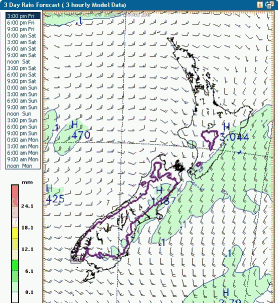
Check out http://www.metvuw.com for some pretty awesome predictions and very colourful graphics
or more explicitly http://www.metvuw.com/forecast/forecast ... noofdays=3 and then click on the day/time you want the detailed map of
or more explicitly http://www.metvuw.com/forecast/forecast ... noofdays=3 and then click on the day/time you want the detailed map of
~ Good roads lead to bad fishing. ~ Eric Wight, Maine Game Warden ~

Re: Whanga Rd 26th July
www.weather.com is also very good as well ....
if it gets to rained out then I guess its Nicks place to find all his beer
if it gets to rained out then I guess its Nicks place to find all his beer
70 series prado (KZJ78) and 90 Series Prado (KZJ95)

Re: Whanga Rd 26th July
Jerry wrote:http://www.weather.com is also very good as well ....
if it gets to rained out then I guess its Nicks place to find all his beer
Get back to work Jerry........
Re: Whanga Rd 26th July
If you guys get this in time also something to sleep on. My air beds have holes in them i have just found out. Sorry for the late message
Sent a txt to Reece, he mentioned something about your bed, and safari tony (the 7 fingered redneck one
70 series prado (KZJ78) and 90 Series Prado (KZJ95)
Re: Whanga Rd 26th July
Jerry wrote:If you guys get this in time also something to sleep on. My air beds have holes in them i have just found out. Sorry for the late message
Sent a txt to Reece, he mentioned something about your bed, and safari tony (the 7 fingered redneck one) has brought his blankies and bedroll. better hope they don't snore
He rung me just before he is going to bring a couple.
Re: Whanga Rd 26th July
Latest just in from Metservice. Seems like Taranaki may miss the worst of it ...
{SWW Event 2008/37.1}
URGENT - IMMEDIATE BROADCAST IN:
NORTHLAND AUCKLAND WAIKATO COROMANDEL PENINSULA BAY_OF_PLENTY TAUPO TAUMARUNUI TARANAKI TAIHAPE WANGANUI MANAWATU WELLINGTON GISBORNE HAWKES_BAY
NOT TO BE BROADCAST AFTER 9:00pm Friday 25-Jul-2008
SEVERE WEATHER WARNING.
ISSUED BY MetService AT 11:28 am 25-Jul-2008
MAJOR STORM EXPECTED TO AFFECT MUCH OF THE NORTH ISLAND THIS WEEKEND A low is crossing the north Tasman Sea today and is expected to deepen rapidly as it approaches northern New Zealand Saturday morning.
The unusually intense low is forecast to move over Cape Reinga late Saturday afternoon then track southeastwards to lie near the Coromandel Peninsula at midnight and near East Cape midday Sunday. A front ahead of the low is expected to bring widespread rain to the North Island by the end of Saturday and gales are likely to affect most parts of the North Island. The heaviest rain should be in Northland,northern Auckland, the Coromandel Peninsula, Gisborne and Hawkes Bay ranges and these areas streams and rivers could rise quickly along with some surface flooding.
East to southeast gales may affect many parts of the North Island with strongest winds gusting to around 120 km/h in parts of Northland, Auckland,Coromandel Peninsula, Waikato, eastern Bay of Plenty, Gisborne, the central North Island,Manawatu and Wellington.MetService advises the public that winds of this strength have the potential to cause damage and make driving hazardous.Boaties are advised to make moorings secure as high winds and large waves are likely about northern and eastern coasts of the North Island.
FOR THE LATEST WEATHER AND FORECAST CHARTS PLEASE GO TO http://metservice.com/default/index.php ... servations
MORE DETAILED INFORMATION FOR EMERGENCY MANAGERS AND TECHNICAL USERS
FOLLOWS:
====================
HEAVY RAIN WARNING
====================
AREAS AFFECTED: NORTHLAND NORTHERN AUCKLAND COROMANDEL PENINSULA WESTERN BAY OF PLENTY GISBORNE HAWKES BAY
FORECAST:
NORTHLAND AND AUCKLAND NORTH OF OREWA
In the period between 6am and 9pm Saturday, 80 to 100mm possible with heaviest falls about northern and eastern hills. Peak intensities of 10 to 15mm per hour.
COROMANDEL PENINSULA BAY OF PLENTY WEST OF KAWERAU In the 24 hours from 9am Saturday to 9am Sunday, 150 to 200mm in the ranges.
On lower lying eastern areas 60 to 90mm possible and west of the ranges 50 to 70 mm.
GISBORNE NORTH OF GISBORNE CITY
In the period from 6pm Saturday to noon on Sunday, 80 to 100mm possible in the ranges. Peak intensities of 10 to 20mm possible with a few thunderstorms Saturday night.
SOUTHERN GISBORNE, AND HAWKES BAY NORTH OF WAIPUKURAU In the 21 to 24 hours from 6pm Saturday 80 to 100mm possible in the ranges. The rain should gradually ease from areas south of Napier around the middle of the day as easterly winds turn southerly. The rain easing farther north towards evening.
====================
STRONG WIND WARNING
====================
AREA AFFECTED: NORTHLAND AUCKLAND WAIKATO COROMANDEL PENINSULA BAY OF PLENTY GISBORNE TAUPO TAIHAPE TARANAKI WANGANUI MANAWATU WELLINGTON
FORECAST:
NORTHLAND
Easterly winds rising to gale during Saturday morning and likely to reach severe gale in exposed places during the afternoon and early evening with gusts around 120 km/h.
AUCKLAND COROMANDEL PENINSULA WAIKATO WAITOMO BAY OF PLENTY TAUPO East to southeast winds rising to gale during Saturday late afternoon or evening.Between 3pm and midnight Saturday in Auckland, and 6pm to 3am Sunday farther south, winds may reach severe gale in some exposed areas with gusts to around 130 km/h.
TARANAKI TAIHAPE WANGANUI MANAWATU WELLINGTON In the period from Saturday midnight to midday Sunday, southeast winds may gust to around 110 km/h at times in some exposed places.
NEXT SEVERE WEATHER WARNING WILL BE ISSUED AT OR BEFORE 9:00pm Friday 25-Jul-2008
Forecast prepared by: Bob Lake
A service provided through a contract with the Crown
(C) Copyright Meteorological Service of New Zealand Ltd 2008
~ Good roads lead to bad fishing. ~ Eric Wight, Maine Game Warden ~
Re: Whanga Rd 26th July
Sounds even better 

Re: Whanga Rd 26th July
EMERGENCY
I had a slight prob last weekend with one of the rear spring clamp thins on my lux breaking... well it didn't break as such, kinda worked itself loose and ... fell off
now I have replaced the missing bugger (and yes, used thread lock this time) but just noticed the farkin bumpstop missing
its the same as the front on the lux as well, if any one doin this trip happins to have 1 spare, I would appreciate or any ideas on how I can get around this, ie, a substitute or do I actually need it, considering the rear susp is quite tall
please, advice etc ASAP
cheers
Dave
Got a Daihatsu Something, hasn't got a Daihatsu engine.... or diffs.... and it doesn't have windows.... or doors.... but its got tyres....
-
Sadam_Husain
- Angry bird
- Posts: 5164
- Joined: Mon Feb 20, 2006 12:00 pm
- Location: WELLINGTON
Re: Whanga Rd 26th July
Windsock wrote:Latest just in from Metservice. Seems like Taranaki may miss the worst of it ...
They might miss the worst of it but there not going to miss the 110kph wind gusts by the look of it
Hope they've got some extra pink blankies to keep themselves warm up there
Cant help you with the Bumpstop Dave but if its any consolation one of my front ones has been missing for 1 1/2 years now
Re: Whanga Rd 26th July
Sadam_Husain wrote:They might miss the worst of it but there not going to miss the 110kph wind gusts by the look of it
Hope they've got some extra pink blankies to keep themselves warm up there
Yep, the overall orientation of the Whanga valley appears to be NW/SE so they'll be exposed to the full brunt of whatever hits up there as they come around some of the headlands etc. Windfall trees may also be sommint to watch for... take some food/ales with those pink blankies in case the afternoon gets closed in...
~ Good roads lead to bad fishing. ~ Eric Wight, Maine Game Warden ~

Re: Whanga Rd 26th July
might sleep in tomorrow - have a great time
Re: Whanga Rd 26th July
yep, maps are showing up to 15 to 20 knot winds but be aware of terrain speed-up as the wind is channeled up the valley... should be an awesome feeling getting knocked around in your trucks by both the ground and the wind/rain
~ Good roads lead to bad fishing. ~ Eric Wight, Maine Game Warden ~
Re: Whanga Rd 26th July
Windsock wrote:yep, maps are showing up to 15 to 20 knot winds but be aware of terrain speed-up as the wind is channeled up the valley... should be an awesome feeling getting knocked around in your trucks by both the ground and the wind/rain
Lots of fun


Re: Whanga Rd 26th July
it's all lies, lies i tell ya!! jerry has edited them


Re: Whanga Rd 26th July
Jerry chatting up his pussy

Jerry wantong us to leave him and his pussy alone....

Jerry wantong us to leave him and his pussy alone....
Re: Whanga Rd 26th July
how's the trip go? are there any pics yet? what about now? are they there yet?
70 series prado (KZJ78) and 90 Series Prado (KZJ95)
-
skid

- Tyre Man
- Posts: 6311
- Joined: Thu Oct 06, 2005 12:00 pm
- Location: WELLINGTON-0272417757
- Contact:
Re: Whanga Rd 26th July
Jerry wrote:how's the trip go? are there any pics yet? what about now? are they there yet?
patience Jerry
you're inbred cousins may not have let them go yet
unless they are already sitting round the campfire plucking banjo strings
80 Series on 35" creepies, manual with twin factory lockers.
0272417757
*CHILLAX BRO.*
0272417757
*CHILLAX BRO.*
Re: Whanga Rd 26th July
just got back, truck bits broken, going to mates with big factory to try to fix nissans and cough my toyota
-
skid
- Tyre Man
- Posts: 6311
- Joined: Thu Oct 06, 2005 12:00 pm
- Location: WELLINGTON-0272417757
- Contact:
Re: Whanga Rd 26th July
madaz068 wrote:just got back, truck bits broken, going to mates with big factory to try
spill the beans
who broke
whos got the first shout when they get back to welly
80 Series on 35" creepies, manual with twin factory lockers.
0272417757
*CHILLAX BRO.*
0272417757
*CHILLAX BRO.*
Re: Whanga Rd 26th July
skid wrote:madaz068 wrote:just got back, truck bits broken, going to mates with big factory to try
spill the beans
who broke
whos got the first shout when they get back to welly
Ask............. hmmm TAZ
-
skid
- Tyre Man
- Posts: 6311
- Joined: Thu Oct 06, 2005 12:00 pm
- Location: WELLINGTON-0272417757
- Contact:
Re: Whanga Rd 26th July
madaz068 wrote:skid wrote:madaz068 wrote:just got back, truck bits broken, going to mates with big factory to try
spill the beans
who broke
whos got the first shout when they get back to welly
Ask............. hmmm TAZ
so he has found out that just coz he went to another brand of vehicle.....
none of them are strong enough to deal with his abuse
and who was next
80 Series on 35" creepies, manual with twin factory lockers.
0272417757
*CHILLAX BRO.*
0272417757
*CHILLAX BRO.*
Re: Whanga Rd 26th July
Some pics


