Holiday season is almost here and I and a few others I know of (North Island 4WDers) may be heading south for the holiday break and I know of a couple heading the opposite direction also. As a keen trout fisherman and not wanting to see this shit spread around via the combination of my two "sports" I figured I would look to see what info I could find on it (esp after reading a reference to it around the Reefton area on this site). After looking around and NOT finding an easy to read and understand list of actions to take and rivers affected, I thought I'd put one together. So, as we sometimes cross waterways here is a list of the cleaning methods for vehicles and tyres and a list of the Didymo affected rivers of the South Island (to date none found in North Island). All information has come from the NZ Biosecurity website http://www.biosecurity.govt.nz/pests/didymo/where-is-it.
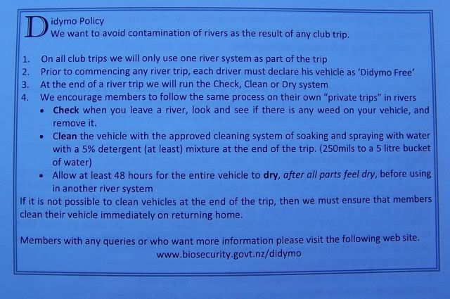
CHECK: Before you leave a river or lake, check items and leave debris at site. If you find any later, treat and put in rubbish. Do not wash down drains.
CLEAN: There are several ways to kill didymo. Choose the most practical treatment for your situation which will not adversely affect your gear.
Non-absorbent items
Detergent: soak or spray all surfaces for at least one minute in 5% dishwashing detergent or nappy cleaner (two large cups or 500mls with water added to make 10 litres); OR
Bleach: soak or spray all surfaces for at least one minute in 2% household bleach (one small cup or 200mls with water added to make 10 litres); OR
Hot water: soak for at least one minute in very hot water kept above 60 °C (hotter than most tap water) or for at least 20 minutes in hot water kept above 45 °C (uncomfortable to touch).
Absorbent items require longer soaking times to allow thorough saturation. For example, felt-soled waders require:
Hot water: soak for at least 40 minutes in hot water kept above 45 °C; OR
Hot water plus detergent: soak for 30 minutes in hot water kept above 45 °C containing 5% dishwashing detergent or nappy cleaner; OR
Freezing any item until solid will also kill didymo.
DRY: Drying will kill didymo, but slightly moist didymo can survive for months. To ensure didymo cells are dead by drying, the item must be completely dry to the touch, inside and out, then left dry for at least another 48 hours before use.
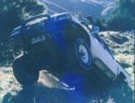
Vehicles should be cleaned thoroughly with a decontamination solution, including spraying the underside of the vehicle and any other parts of the vehicle that have had contact with river or lake water. Commercial carwashes with an underside spray would be suitable. For tyres, see the following tyre section.
The decontamination solution should be left on for at least one minute and may then be rinsed off with water that has come from a town water supply.
Drying is an acceptable alternative method, provided that all components are completely dry to the touch, inside and out, and then left dry for at least another 48 hours before entering a different waterway.
If you do not want to decontaminate your gear, you should restrict use to a single waterway."
"Tyres which have been backed into streams or used for stream crossings must be carefully checked for clumps of algae and other debris within the treads and then scrubbed, soaked or sprayed and flushed with a cleaning solution for the required treatment time. Tyres may then be rinsed using water that has come from a town water supply.
Drying is an acceptable alternative method, provided that all components are completely dry to the touch, inside and out, and then left dry for at least another 48 hours before entering a different waterway.
If you do not want to decontaminate your gear, you should restrict use to a single waterway.
After reading this I guess mud can be considered debris and should be left at site
Anyhow, the list is detailed to the point of river name, location of didymo sample and NZ map grid co-ordinates. Obviously, not all of these NZ map grid points on the affected waterways will be accessible to 4WD but downstream reaches may well be.
- Canterbury Region
- Lake Hood
manmade channel feeding Lake Hood from Ashburton River
2412010 5692980 - Macaulay River
Where 4 Wd track crosses true left side stream at the top of Mt Gerald Island
2313935 5715946 - Orari River
Gorge
2364810 5696130 - Ohau canal 4
c. 500 m above Ohau C power station
2284605 5648381 - Ohau canal 3
Benmore Salmon farm
2280936 5652029 - Cass River
True left lower Cass
2309379 5700146 - Rokeby Stream
Tributary up-stream of Rokeby Hut
2465870 5863610 - Otematata
SH 83 bridge Otematata village
2287990 5618738 - Omarama Stream
Omarama
2268690 5631370 - Twizel River
Lake Poaka
2278409 5662958 - Dobson
500m u/s confluence with Hopkins
2260445 5673997 - Ashburton River
South Branch Mayfield Valetta Rd Bridge
2391462 5717349 - Opuha
Skipton Bridge
2348136 5678815 - Opuha
Below dam
2341972 5685580 - Opuha
Chota Bari Farm
2349837 5672872 - Ohau River
c. 500 m above Lake Ruataniwha
2272604 5655283 - Lake Ohau
Boat launch at Weatherall Motels (head of lake) West Side
2256131 5665906 - Lake Ohau
Boat launch opposite Ohau Lodge (West side of Lake)
2255758 5659511 - Opihi
Waipopo
2376190 5658380 - Rakaia River
Steele Road end. W12
2415185 5730563 - Rakaia
SH 1 bridge South Side
2432748 5716754 - Rangitata
At gorge
2365065 5716020 - Ahuriri River
Top end of native cutting gorge
2244825 5641180 - Ahuriri River
Approximately 1km above native cutting gorge
2243645 5641540 - Ahuriri
birch creek access
2242661 5643500 - Rangitata Diversion Race
Near Fish Screen
2368845 5713130 - Hurunui
500m below SH 1 bridge
2518536 5812096 - Hakataramea
1.3 km from SH82
2311228 5607316 - Rangitata
Arundel
2373630 5691320 - Rangitata
Badham Rd
2388660 5675630 - Rangitata
SHW1 Bridge
2381860 5682855 - Rangitata
u/s of lagoon in flowing reach
2390722 5668302 - Hurunui
Jollie brook Access
2455911 5823347 - Hurunui
u/s Sth Branch confluence
2456897 5820161 - Rangitata
u/s of lagoon
2390806 5668301 - Maerewhenua
Maerewhenua
2322860 5586090 - Tasman
Glentanner Stn
2280226 5696165 - Deep Creek
at Clayton road bridge
2338967 5692339 - Hurunui
about 1 km before gate at Sisters Stream, off road though gate towards Hurunui, pool in river
2454510 5825430 - North Opuha
at Clayton Rd bridge
2339955 5695624 - North Opuha
at clayton settlement rd bridge
2339609 5692718 - Stoney Creek
above nth opuha confluence
2336389 5698008 - Tekapo
Roughly halfway between Haldon Crossing and Iron Bridge, TWI08
2288556 5649563 - Tekapo
below vehicle crossing to haldon
2287666 5648570 - Waihao
Bradshaws Rd Br
2364182 5601495 - Twizel River
Twizel at SH 8
2279268 5657308 - Ohau
D/s Twizel confl
2286211 5648031 - Ahuriri
Birchwood Road
2247429 5635358 - Waitaki
Glenavy
2359898 5585380 - North Opuha
Stoney Creek
2336440 5698040
Marlborough Region
- Wairau
Wash Bridge
2517900 5943265 - Wairau
Dip Flat
2503564 5925767 - Clarence River
Downstream of Jacks Pass, where the pylons cross the river.
2496013 5861595
Otago Region
- Pomahaka River
Hamiltons Flat
2212060 5498720 - Nevis River
U/S of Nevis Crossing
2195309 5551005 - Thomsons Creek
Thomsons gorge
2239620 5574210 - Kakanui River
Robs Crossing
2337541 5567457 - Kakanui River
Five Forks
2333410 5570050 - Nevis River
Wentworth Station
2197595 5563885 - Moke Creek
200m below Moke Lake
2160956 5569896 - Camp Creek
Camp Creek ford
2224569 5605103 - Route Burn
Lake Sylvan footbridge
2139039 5598695 - Timaru River
d/s bridge
2217485 5623470 - Hunter River
Near mouth
2227350 5652210 - Manuherikia River
Blackstone Bridge
2256490 5576030 - Manuherikia River
Galloway Rd Bridge
2229674 5547436 - Kakanui River
Gemmels Crossing
2339166 5563517 - Kakanui River
Mill Dam
2340284 5559287 - Kakanui River
Maheno
2340158 5558272 - Dart River
Main Road bridge
2140202 5593217 - Cardrona River
Mt Barker
2202763 5599188 - Young River
Ram Flat
2207508 5660665 - Lake Dunstan
Bendigo Ramp
2216955 5578602 - Lake Dunstan
Pisa Moorings
2213805 5574345 - Shotover River
Tuckers Beach
2173000 5570970 - Kawarau River
ChardsRd
2184453 5569728 - Lindis River
Ardgour Rd
2228786 5589302 - Greenstone River
between fishtrap and creek
2142700 5575470 - Diamond Creek
Glenorchy
2145170 5592060 - Clutha River
Stirling Cheese Factory raw water inlet pump
2261745 5434500 - Clutha River
Kaitangita main Rd
2266310 5434240 - Lake Wakatipu
lake edge about 250 m south of Geordies Creek, Glenorchy - Queenstown Road
2150092 5573462 - Wilkin River
U/S of Makaraora confluence
2204911 5652912 - Makarora River
u/s Cameron Flat
2214072 5666349 - Clutha River
d/s Roxburgh dam
2221670 5518230 - Matukituki River
u/s of Cattle Flat
2192220 5611430 - Clutha River
Beaumont
2239905 5482585 - Fraser River
Marshall Rd
2223977 5544823 - Von River
Mouth
2150770 5558930 - Lake Dunstan
Crippletown
2217957 5579773 - Lake Dunstan
Rocky Point
2217246 5579256 - Lake Dunstan
Rocky Point
2217256 5579174 - Von River
2 km D/S from Old Nicholas Ford
2146300 5555520 - Clutha River
Red Bridge, Luggate
2215629 5602004 - Von River
Mouth
2150118 5559261 - Clutha River
Red Bridge, Luggate
2215629 5602004 - Hawea River
Maungawera Bridge
2212311 5610767 - Hawea River
Albertown reserve
2208390 5607510 - Motatapu River
Mt Aspiring Rd, ~2km before Treble Cone turnoff
2188684 5609903 - Clutha
U/s of Salmon Farm intake - Waitaki
Kurow - Buller River
Longford
Southland Region - Tomogalak Stream
Biggar Road
2163526 5490055 - Deep Cove
Tail Race 200m u/s from mouth of race true left
2054075 5510172 - Ettrick River
Upstream end of shingle fan above Log Cabin
2089945 5537200 - Ettrick River
Just below trib on true left above log cabin
2090025 5537149 - Acton Stream
Hillas Road bridge
2140925 5500470 - Ettrick Burn
150 u/s from lake
2095569 5537587 - Pleasant Creek
Dunrobin Valley Road bridge
2122500 5484100 - Ettrick River
above first rapid u/s river mouth
2095473 5537602 - Lake Manapouri
near Iris Burn
2086820 5511125 - Waimea Stream
Mandeville
2184599 5460728 - Weydon Burn
Centre Hill Road
2129570 5502590 - Braxton Burn
u/s Hamilton Burn Confluence
2131426 5489455 - Eyre Creek
Shepherd Creek Hut ford
2152370 5523905 - Mataura River
Keowns Road bridge
2171999 5480409 - Mataura River
Riversdale - Waikaia Road
2180896 5473475 - Mataura River
u/s Tomogalak confluence
2170446 5485119 - Lake Te Anau
Ewe Burn
2099086 5527665 - Loch Burn
Edge of Lake Te Anau
2088586 5548446 - McIvor Burn
Edge of Lake Te Anau
2082209 5548345 - Cromel Stream
Mossburn Five Rivers Road
2150595 5499501 - Mararoa River
upstream North Mavora Lake
2130064 5548417 - Tunnel Burn
Lakeshore at river mouth
2096643 5532708 - Point Burn
lake shore at river mouth
2096718 5529007 - Lake Te Anau
Site 1
2096915 5530066 - Lake Te Anau
Site 2
2096915 5531048 - Lake Te Anau
Site 3
2096676 5532000 - Wairaurahiri River
next to private lodge
2064243 5423130 - Mystery Burn
on rocks 5m u/s from lake edge
2086943 5526996 - Snag Burn
between 1st and 2nd rapids u/s rive mouth
2089111 5544779 - Dale Creek
400 metres upstream Mararoa River confluence
2117880 5511090 - Hollyford River
Marian swing bridge
2122790 5588500 - Hollyford River
bottom of clearing by hollyford camp
2125343 5594090 - Hollyford River
road end
2123876 5601399 - Eglinton River
d/s Mackay Creek confluence
2115600 5559440 - Hamilton Burn
Matuku bridge
2135680 5487505 - Mataura River
d/s Black bridge SH 6
2167374 5512053 - Princhester Creek
Princhester Road
2115420 5504000 - Upukerora River
downstream Te Anau - Milford Highway
2098352 5520201 - Aparima River
Dunrobin Station
2130293 5485471 - Whitestone River
Glen Echo Station
2111200 5523400 - Oreti River
d/s Lochiel Bridge
2145508 5433492 - Oreti River
d/s Weydon Burn confluence
2132400 5499537 - Oreti River
Three Kings cableway
2129663 5517730 - Oreti River
Wilson's Crossing Road
2146921 5428979 - Oreti River
Dipton
2150066 5469480 - Upper Waiau River
Queens Reach
2095443 5511813
Tasman Region - Cobb River
u/s Cobb Dam. Camping ground.
2477512 6008725 - Matiri River
approx. 3km upstream SH bridge
2454276 5937997 - Motueka
Woodstock
2495112 5994300 - Glenroy
2455182 5909290 - Six Mile
2453521 5927091 - Matakitaki
1 km u/s SH 6
2453424 5933190 - Owen River
Farrels
2470218 5953961 - Motueka
300 m u/s SH60 br
2510168 6012124 - Takaka
at Harwoods
2493040 6019630 - Takaka
at Paynes ford
2493950 6035900 - Takaka River
bridge 2km u/s Harwoods
2492195 6018580 - Gowan
1 km u/s Buller confluence
2474357 5942976 - Buller
L. Rotoiti outlet u/s Br
2495150 5933820 - Buller
u/s Raits Rd Br.
2466350 5945400 - Buller
Rait's Road
2466400 5945400 - Buller
below Gowan confluence
2469300 5944800
West Coast Region - Totara River
Follow Moorhouse Rd, Ross towards beach. Then turn right and follow track to Old railway bridge.
2331219 5811941 - Mikonui River
Turn of SHWY and take Boldhead Road. On right is gate. Follow track past gate to end.
2327157 5808851 - hokitika River
Up Gibson Quay just west of milk factory, True right.
2344205 5829290 - Grey River
True left of river above the bridge on the main road.
2400445 5878964 - Hokitika River
Approx 100m downstream from Hokitika Gorge swingbridge, true right of river
2348500 5804150 - Hokitika River
Arthurstown Road on sharp bend, track leads to true left of river, near gravel heaps
2345420 5827850 - Inangahua River
Brazils Road, above ford at shingle track.
2412859 5906108 - Waitahu River
True left of river of O'Gradys Road, directly under main trunk bridge.
2414420 5903350 - Arahura River
Just downstream of Arahura rail bridge on true left of river.
2348402 5835351 - Kakapotahi (Little Waitaha)
Upstream of Old Church Backpackers
2324290 5799875 - Kakapotahi River (Little Waitaha)
Downstream of Old Church Backpackers
2323050 5800689 - Kakapotahi (Little Waitaha)
SH6
2323380 5800650 - Haast
Burke Flat airstrip d/s Burke confluence
2218820 5680995