
Thinking about going for a look up the poulter river track on sunday.
Anyone know if permission is needed to do this one?
Will be leaving approximately 8.30 on sunday and planning to spend the most part of the day up there.
So far just two trucks going up and neither of us have been up there so we dont really know what too expect.
if anyone wants to come along we can sort out a spot to meet later on in the week.Anyone welcome, especially if you know how to get there!
poulter river trip
poulter river trip
89 lwb patrol, Mud comes standard

Went up there about a month ago not sure if you have to get permision as went up with a club
I know there is on gate to go through when you turn of shingle rd not sure if locked or not then you can go up river bed or go up goat track to side and then come back down river bed
watch out for sand flies they made a meal of us

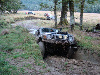
This was crossing the mak to get to the Poulter the way we went in but you can get in off a shingle rd
think this rd is called mount white rd you go over mak past andrews shelter and keep going just before you get to bridge that goes over poulter you take a left and go through gate (if you can and you are allowed)
Kev
I know there is on gate to go through when you turn of shingle rd not sure if locked or not then you can go up river bed or go up goat track to side and then come back down river bed
watch out for sand flies they made a meal of us
This was crossing the mak to get to the Poulter the way we went in but you can get in off a shingle rd
think this rd is called mount white rd you go over mak past andrews shelter and keep going just before you get to bridge that goes over poulter you take a left and go through gate (if you can and you are allowed)
Kev
-
Steve_t647

- Hard Yaka
- Posts: 998
- Joined: Wed May 17, 2006 12:00 pm
- Location: Christchurch City, In front of the computer
Not sure but I understand permission is not required.
It is a good trip, there is a bridge shortly after the turnoff from the highway and enough room for the vehicles to gather at this point. It is alping so the rivers are not too warm.
Arthurs Pass National park starts up near the top and there was quite a big slip to drive down at one point (drove up the track down the slip onto the river then back to the track).
Coming down the river is quite good, remember to get out where you see the mount white station bridge
-
hosehustler
- Hard Yaka
- Posts: 2051
- Joined: Thu Jan 06, 2005 12:00 pm
- Location: Brooklnands
check the river flows, heavy rain expected in the alps, Poulter will be high and dirty  if you head down the shingle scree at the end of the track to the river and can't get back up...the only way out is down stream.....
  be careful about your decision to head down into the Poulter river bed proper
follow instuctions of how to get there via Mt White rd (already posted), don't bother with trying to access via the Waimak, it will be high and private property becomes an issue
Believe it to be public access, go through gate om left before you cross the poulter follow track up stream until you get into the Poulter river bed, at the confluence of another river (can't remember it's name) you'll see some poles across the Poulter, this signifies the National park bounday DON'T go any further upstream
Have a good day, watch the weather (especially the river flow), stick to the track
I hate signatures
I know the area very well and it is a reasonable trip.
You will need to make a call at Mount Brown Steam (as this is as far as you can drive the track as from there you are in a National Park) as to your choices of returning, you can go back via the track or via the Poulter River, as once you decend the shingle slide at Mt Brown Stream getting back up can be an issue so check out your plan at that point before proceeding. Other than that it is a great trip, and no permision required so long as you stick to the track and the river bed.
I may be available as I will already be in the area so if I have the time I may very well catch up with you guys up there, see how we go, but have a good trip and as already pointed out watch the weather.
Paul