In light of the Doc issues at the moment and several comments raised in some of the threads I thought it would be an idea for us to compile a list of 4wd tracks and areas on the west coast.
I will start the ball rolling and will add in map co-ordinates later where possible to assist identifying tracks as some areas are known by different names etc.
If anyone thinks this is a bad idea say so and I'll delete the thread.
I thought this would also be a good way for people to identify 4wd areas they were not aware of
So in no relevant order
New Creek to Denniston
Denniston Area
Totara/Tailings
No Name Road
Cockeye Creek
Mt Greenland
Big River Area
Montgomeries Hut
Waitahu
Larrys Creek
WEST COAST 4WD AREAS
WEST COAST 4WD AREAS
Last edited by Smurf on Mon Jan 19, 2015 5:43 pm, edited 1 time in total.


ministaircase (reefton area)
Wankel hill
petrolhead hill
coppercreaak mine
barn bay (near Haast, could be private land though)
mokinui ( not sure on spelling)
wauipuna tunnel/nobles creek
I will n ame more as I thin k of them.
My plan was to get the wording of the CMS changed so that it becomes a living document. By this I mean that the process is open and the naming of routes is an ongoing process.
Al
rain, hail, sleet or snow, we go!

-
Steve_t647

- Hard Yaka
- Posts: 998
- Joined: Wed May 17, 2006 12:00 pm
- Location: Christchurch City, In front of the computer
Not sure if others have other names but this is some that I have done and seen published and would like to do. This is where over 10 years the names and routes we take may be different, I have no GPS data for the route's and we were lead not the group leader. Some may be forestry
BURNETTS FACE PYLON TRACK
SULLIVANS MINE LOOP TRACK
MOUNT FREDRICK TRACK
THE TAIPO VALLEY
THE WAIPUNA TUNNELS
THE BIG RIVER GOLD MINE
THE ROSS/RUATAPU RAILWAY
THE MOUNT GEENLAND TRACK
THE LIVERPOOL BILLS CREEK TRACK
STOCKTON PLATEAU
THE BLACKBURN TRACK
THE TIN TOWN TRACK
BURNETTS FACE PYLON TRACK
SULLIVANS MINE LOOP TRACK
MOUNT FREDRICK TRACK
THE TAIPO VALLEY
THE WAIPUNA TUNNELS
THE BIG RIVER GOLD MINE
THE ROSS/RUATAPU RAILWAY
THE MOUNT GEENLAND TRACK
THE LIVERPOOL BILLS CREEK TRACK
STOCKTON PLATEAU
THE BLACKBURN TRACK
THE TIN TOWN TRACK
I have a document produced by Doc with 4x4 tracks on doc land. These are listed by them and so are obviously available to use for 4x4 and there should be no issues with access. also has some good info on use of tracks etc. I may have posted it here in the past but will see if I can dig it up again
Sold my 1985, BJ74 MWB Landcruiser, rear locker, 33" MTs, snorkel, PTO winch, solid bars all round, spotties, AM CB etc.
Now just a 1994, 1kz Surf, pretty standard.
Now just a 1994, 1kz Surf, pretty standard.
fweddy wrote:I have a document produced by Doc with 4x4 tracks on doc land. These are listed by them and so are obviously available to use for 4x4 and there should be no issues with access. also has some good info on use of tracks etc. I may have posted it here in the past but will see if I can dig it up again
Ah here is is
South Island:
http://www.doc.govt.nz/upload/documents/parks-and-recreation/activity-finder/four-wheel-driving/4wd-south-island.pdf
North Island
http://www.doc.govt.nz/upload/documents/parks-and-recreation/activity-finder/four-wheel-driving/4wd-north-island.pdf
West coasts tracks listed by them are:
Denniston Circuit
Denniston to Iron Bridge
Greens Beach Rd
Okarito Forest Block
Waitahu River Rd
No Name Rd and Cockeye Creek Rd
Big River Rd
Napoleon Hill Rd
They state if there are access issues
Sold my 1985, BJ74 MWB Landcruiser, rear locker, 33" MTs, snorkel, PTO winch, solid bars all round, spotties, AM CB etc.
Now just a 1994, 1kz Surf, pretty standard.
Now just a 1994, 1kz Surf, pretty standard.
albundy wrote:Napoleon Hill Rd
That's interesting as it is currently in a Wilderness area under the CMS review which would require an access permit.
Al
That was published Aug 2007
The note they say on Napoleon Hill Rd is
Landowner permission required: Robin and Malcolm Smith Ph 03 7323 849 Ahaura, east of Greymouth, SH 7. Begin at turn-off on Orwell Creek Rd.
Sold my 1985, BJ74 MWB Landcruiser, rear locker, 33" MTs, snorkel, PTO winch, solid bars all round, spotties, AM CB etc.
Now just a 1994, 1kz Surf, pretty standard.
Now just a 1994, 1kz Surf, pretty standard.
[quote="fweddy
You drop in at the bridge below the property and drive up the river to gain access to Nobles creek/napoleons Hill. That way you won't have to pay to cross their land
[/quote]Landowner permission required: Robin and Malcolm Smith Ph 03 7323 849 Ahaura, east of Greymouth, SH 7. Begin at turn-off on Orwell Creek Rd.
You drop in at the bridge below the property and drive up the river to gain access to Nobles creek/napoleons Hill. That way you won't have to pay to cross their land
Smurf wrote:Landowner permission required: Robin and Malcolm Smith Ph 03 7323 849 Ahaura, east of Greymouth, SH 7. Begin at turn-off on Orwell Creek Rd.
You drop in at the bridge below the property and drive up the river to gain access to Nobles creek/napoleons Hill. That way you won't have to pay to cross their land
Yep, That's the way we did it, but I notice this is talking about going in at the other end. Where are the Smiths? are they the ones a bit further up the road from the bridge at the river end?
We also noticed coming out onto the Orwell creek road there is a sign you see in your rear view about not proceeding without access. About at the edge of the forest section.
Sold my 1985, BJ74 MWB Landcruiser, rear locker, 33" MTs, snorkel, PTO winch, solid bars all round, spotties, AM CB etc.
Now just a 1994, 1kz Surf, pretty standard.
Now just a 1994, 1kz Surf, pretty standard.
-
PeterVahry
- Hard Yaka
- Posts: 688
- Joined: Wed Mar 01, 2006 12:00 pm
- Location: Auckland

-
PeterVahry
- Hard Yaka
- Posts: 688
- Joined: Wed Mar 01, 2006 12:00 pm
- Location: Auckland
West Coast 4WD Roads/Tracks
Its good to get the ball rolling on a list. In the Draft of the CMS it gives some examples as Peter has pointed out. DOC have the difficulty as we do that they simply dont know all the places and if they do have different names than we do. Indeed you may have a different name for a place than I do.
The other difficulty is that (we will call them roads as this is the term in the CMS) roads may cross several juristictions. DOC Land onto legal road onto private land etc.
DOC West Coast have said that the Conservation Authority are unlikely to approve of the way they have it in the CMS (using examples) That the Conservation Authority will require them to list the roads. This can be got around by taking out the names already used as examples and indicating in the CMS that a list will be estabished on thier Web Site. As this CMS is a vision of how it will be in 2017 then that list can be added to until then and perhaps beyond.
DOC on their Web Site have GIS Mapping. It takes a bit to use it. (I trundled off to a local DOC Office and got them to show me how to work it) Once you have all the settings right you can use YOUR Topo Map Grid references to GO TO a place. Once there you can find out the Land Number and the type of DOC land. ie. Conservation, Stewardship, Eccological Area etc. You can also relate the numbers to the places listed in part 2 of the Draft CMS.
What none of it tells you is why it is held as for example an Eccological Area. It appears the only way you can find out is by phoning DOC.
So Napoleans Hill/Waipuna Tunnels as given in an earlier posting could be held for any reason from Native Snails to Historic Value.
It would be good to know why these areas are special, then we can help by taking extra care.
A good example of this is Red Rocks around the Wellington Coast. There is an area of rare plants. DOC have complained that trucks are damaging the area. If they would tell us via signage(may have happened now) we could take care.
So keep up the good work. Keep the list coming and I will create a Data Base listing Grid references and try and establish land unit numbers.
Cheers
Graham
Last edited by OVERSZ on Fri Sep 28, 2007 8:00 pm, edited 1 time in total.


No Name Road
Some of No Name Road is Legal Road some is on private land. I understand that the gate shuts off an active logging area and that it is still possible to go from Marsden to the Greenstone River.
When I spoke to the WDC a few weeks ago they were not aware of any gate closing No Name Road.
Anyone with confirmation one way or the other would be good.
Graham
When I spoke to the WDC a few weeks ago they were not aware of any gate closing No Name Road.
Anyone with confirmation one way or the other would be good.
Graham
When I was up that way following the instructions in Siblys book we hit a locked gate about 3kms in. Had to go around to cockeye creek, Still have never done no name
Sold my 1985, BJ74 MWB Landcruiser, rear locker, 33" MTs, snorkel, PTO winch, solid bars all round, spotties, AM CB etc.
Now just a 1994, 1kz Surf, pretty standard.
Now just a 1994, 1kz Surf, pretty standard.

when going to noname road, cockeye creek or liverpool bills creek it is advisable to get a permit from timberlands in greymouth.they can ley you know if there are any closures in the area due to logging operations. Part of the orewell creek road may be on private land and some of that land is being developed at present.will try to get more info onthis and post it when i can , but my current understanding is that the landowners have no intention of denying access.
Orwell Creek Road/Napoleons Hill
I'm told there is a name and phone number on the Gate. If anyone has this could they post it please.
I'm informed the Land Owner is happy to have 4WD in there. He just would like to know who.
I've also asked DOC if they have disposed of the land as DOC GIS mapping shows this to be still in the Granville Eccological Area.
Cheers
Graham
I'm informed the Land Owner is happy to have 4WD in there. He just would like to know who.
I've also asked DOC if they have disposed of the land as DOC GIS mapping shows this to be still in the Granville Eccological Area.
Cheers
Graham
Re: WEST COAST 4WD AREAS
Re: Napoleon Hill Access.
As The land Owner At The Orwell Creek Ahaura End
I Would Like to notify you all
That in veiw of continued DAMAGE
(To Gates, Locks, Posts, Fences And Paddocks being riped up by 4x4s.)
Should this Continue
The Road Will be destroyed with nil access
At The East end of our property.
At present we are still allowing access but have been advised by
the POLICE to close access.
We Will Consider Requests From Members Of The Public
For Access Across Our Farm To Napoleon Hill
By Prior Arrangement Only
Please Phone
03 732 3849
0211314632

Re: WEST COAST 4WD AREAS
foresters wrote:Re: Napoleon Hill Access.
As The land Owner At The Orwell Creek Ahaura End
I Would Like to notify you all
That in veiw of continued DAMAGE
(To Gates, Locks, Posts, Fences And Paddocks being riped up by 4x4s.)
Should this Continue
The Road Will be destroyed with nil access
At The East end of our property.
At present we are still allowing access but have been advised by
the POLICE to close access.
We Will Consider Requests From Members Of The Public
For Access Across Our Farm To Napoleon Hill
By Prior Arrangement Only
Please Phone
03 732 3849
0211314632
Sorry to hear there are the idiots out there still.
People can't seem to get it through their thick skulls that it is a privelege, not a right to access private land.
I certainly hope it doesn't get to the stage where access is lost, but it is decent of you to bother posting your contact details, and airing your concerns, rather than closing access.
-
Bulletproof
- Hard Yaka
- Posts: 1775
- Joined: Sat Apr 19, 2008 8:18 pm
- Location: Nelson
Re: WEST COAST 4WD AREAS
DOC are currently working on this and have arranged a meeting with John Randle who has named nearly all the tracks on the west coast. John rang me last week and they have made a definite appointment.
In my discussions with DOC they may even put a grading on the tracks .
A lot of the zonings have never been properly established since they took over from the forest service and these will have to be looked at as well.
Cheers Richard
In my discussions with DOC they may even put a grading on the tracks .
A lot of the zonings have never been properly established since they took over from the forest service and these will have to be looked at as well.
Cheers Richard
Never say die, up man and try
Re: WEST COAST 4WD AREAS
foresters wrote:Re: Napoleon Hill Access.
As The land Owner At The Orwell Creek Ahaura End
I Would Like to notify you all
That in veiw of continued DAMAGE
(To Gates, Locks, Posts, Fences And Paddocks being riped up by 4x4s.)
Should this Continue
The Road Will be destroyed with nil access
At The East end of our property.
At present we are still allowing access but have been advised by
the POLICE to close access.
We Will Consider Requests From Members Of The Public
For Access Across Our Farm To Napoleon Hill
By Prior Arrangement Only
Please Phone
03 732 3849
0211314632
I too wish to thank you for voicing your concerns and posting your contact details. Well done indeed.
It is however a shame that there are some that will ruin it for all of us.
Ok people, move along. Nothing to see here. Thank you, move along.
Ph 0212078472
Ph 0212078472
Re: WEST COAST 4WD AREAS
"foresters",
Thank you for coming on site and expressing your concerns and giving us contact details so this beautiful piece of land can still be accessed by responsible 4WDers. I hope in the very near future to be able to give you a call to gain access through your property.
Thank you,
Kevin Fitzgibbon,
FITZY.
Thank you for coming on site and expressing your concerns and giving us contact details so this beautiful piece of land can still be accessed by responsible 4WDers. I hope in the very near future to be able to give you a call to gain access through your property.
Thank you,
Kevin Fitzgibbon,
FITZY.
Re: WEST COAST 4WD AREAS
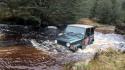
I went through No Name Road about 3 weeks ago didn't see any gates [ not sure where they are ] but did have a bit of a hassle crossing the Greenstone a bit in flood but found away across, also the track was a bit washed in parts but nothing to bad ..i sometimes stay just on the other side of the Greestone River at a mates place so do these tracks quite regularly
Also thanks to Foresters,its great to see on this forum and have their say and their phone numbers it must piss them off no end.
Must admit our family went through Napoleon a month or so ago from the other end and got to the sign that said locked gate so turned round and went back [ neat trip back as well ],we didnt know the road was locked as it was open the last time we went through ..... I HOPE 4X4'R'S HAVE THE BRAINS TO RESPECT THESE FARMERS and just give them a ring,simple really
I have 4wdrived for many years in the South Island and the North Islands and have never been turned away by farmers and Satation owners,all they want is for you to ask and respect their land,they really are bloody good and sometimes put up with a lot of shit,and most understand 4x4ing as they do it themselve's for a living a lot of the time,down South i've had station owner's come 4x4ing with us for the day and show us alsorts of places [ Tekapo ]
Last edited by furnace on Sun Jun 15, 2008 9:28 pm, edited 1 time in total.
-
nuts
- Hard Yaka
- Posts: 645
- Joined: Wed Jul 19, 2006 12:00 pm
- Location: somewhere arround westcoast offroading usually
Re: WEST COAST 4WD AREAS
there r a lot more tracks
seddonville ... multiple tracks there
costello hill u can spend days in there
fourmile
smiths clearing
karamea bluffs
mount frederick
lots of looptracks up denniston
there are others but
seddonville ... multiple tracks there
costello hill u can spend days in there
fourmile
smiths clearing
karamea bluffs
mount frederick
lots of looptracks up denniston
there are others but
people think i have a problem with insanity .... i dont i enjoy every minute ..... 0278900597
Re: WEST COAST 4WD AREAS
Played around up Denniston a bit,where about is Costello Hill,where do you start from,i mite have a look next time i'm over that way ,i've got a mate in Whimangaroa, will give me an excuse to see him ..lol..