The opinions and viewpoints expressed by users of Offroad-Express Forums are wholly their own and not necessarily those of Offroad-Express. https://www.offroadexpress.kiwi:443/Forums/
Just wondering what the track through Glenthorne station up into the Wilberforce valley is like? Looking on google maps the track runs up the true left of the valley, and the track can be seen to go up quite a way then sort of disappears near the Fanghill hut.
I have a fairly standard Suzuki, 29" mud tires & skid plate - it looks as though I'd get to the hut OK as there aren't many river crossings on that track.
Just wondering what the main river is like up that far and whether it is possible to find crossings in the braids? Just looking for places to check out on short hunting trips so crossing the river in the truck would be ideal as I could take a big tent and cooking equipment.
Cheers for any help
Re: Wilberforce Track
Posted: Mon Mar 26, 2012 3:04 pm
by Bulletproof
You can easily drive to Fanghill hut which is beside a huge shingle fan. After that as long as there is no snow melt or rain you can go for miles to where the tramping track leads to the Westcoast but the boulders start getting huge and it turns into tiger country.
The Wilberforcre is not a river to be messed with if it is up because it has a powerful current and it can come up real quick even if it is fine in Canterbury because it is at the back of Hokitika. Most of the crossings are easy but there is one that can't be avoided by some rocks and can be quite deep and swift
I would ring up the station and ask the owner for his advice because you can't get up there without driving past the sheds and house.
Cheers Richard
Re: Wilberforce Track
Posted: Mon Mar 26, 2012 7:00 pm
by rokhound
Have done a few overnighters into the Wilberforce. Awesome country. we set up at Urkerts hut which is on the way to Brownings pass (the original route to the coast before Arthurs pass). We have shared space with some hunters there each time we went and everytime they managed a head of something. As Richard stated, don't mess with the river as it flows quite quickly and has a fair bit of force. There is quite a bit of boulder bashing to do to get to the basin (ie it is not just a drive in the park on a well formed metal track), but the basin area is absolutely huge when you get in there. Of course we went in looking for the ugliest shit we could find to drive on, so the big shingle fans and waterfall run offs with garage sized boulders held great appeal
Re: Wilberforce Track
Posted: Mon Mar 26, 2012 7:13 pm
by tomsoffroad
As above...... Awesome country Its home Make sure you take extra food and clothing as there is a very real chance that the weather may force you to have a holiday up there. Water level gets very high very fast As you'll see if you go, its a HUGE catchment. If you look very closely at some of the rocks you will see where Rok fell over. Look for blue and white paint
Re: Wilberforce Track
Posted: Mon Mar 26, 2012 8:49 pm
by drive it ...
Work your way across the Fanghill Stream (usually down the bottom near the main river) and then you pick up the track again up to Bristed stream. Thats where I usually parked (unmodified 96 LWB prado). Like guys above have said, dont take main river lightly, although on good forecast this time of year it's not normally a problem.
Re: Wilberforce Track
Posted: Mon Mar 26, 2012 8:53 pm
by dtchch
Cheers guys very helpful I probably wouldn't drive up too much further than the Fanghill hut if it was too tricky, the Moa valley looks like a good place to walk the rifle but would mean crossing the river preferably.
Definitely on the to do list. I went on a trip up the Avoca which I remember as being a long bumpy ride but the river crossings weren't too bad.
I really need to get some lift on that Zuk!
Re: Wilberforce Track
Posted: Mon Mar 26, 2012 10:14 pm
by Lawrence
Richard do you have any pictures?
I am also looking at going up the Mathias at some stage, any of you guys driven very far up there.
DTCHCH be warned Moa stream etc gets alot of people threw it during the roar.
Cheers
Re: Wilberforce Track
Posted: Tue Mar 27, 2012 5:17 am
by rokhound
The trip up the Avoca to the Avoca hut is a doodle in comparison. The Wilberforce can be done in unmodifed rigs, it just takes a bit longer. (last time we were at Urkerts hut we shared with some bangstick guys who were in a series 1 disco).
Re: Wilberforce Track
Posted: Tue Mar 27, 2012 7:13 am
by Bulletproof
Lawrence wrote:Richard do you have any pictures?
I am also looking at going up the Mathias at some stage, any of you guys driven very far up there. Cheers
I do have some video but can't find it at the moment.
If you are going up the Mathias you are probably better to go via the Rakaia at Manuka Point rather than the Wilberforce at Mt Algidus. The Rakaia is an easy crossing in the winter but in the spring thru summer you have 5 hrs from sun up for the snow melt to reach Manuka point and bring the river up.
I have done lots of deep water crossing but the biggest 4 wheel drive scare I have ever had was in the Wilberforce. We were going down river from Glenthorne to Mt Algidus and had crossed about 4 braids which were colored. When we came to the next one the pressure waves were about a Metre high and we realized the river was rising rapidly from rain on the Coast. This made us panic as to whether we would be able to re-cross the ones we had crossed earlier to get out of the middle of the river bed.
Luckily we did and things worked out OK but we could easily have been stuck with no way out.
Mt Algidus Station has a Grader with a trailer 6 ft high to cross the Wilberforce with and they still get trapped for weeks at times.
That is why I made the comment not to mess with that river but in saying that I have driven the section between Glenthorne and Mt Algidus a couple of times and it is a nice drive.
Cheers Richard
Re: Wilberforce Track
Posted: Tue Mar 27, 2012 7:19 am
by NJV6
If you enjoy that area 'A river rules my life' by Mona Anderson is a great read. It tell of her as a city girl marrying Ron and went on to spend 40 years at Mt Algidus.
Here is the Holmes show clip
Re: Wilberforce Track
Posted: Tue Mar 27, 2012 12:22 pm
by tomsoffroad
Great video. Man I miss that part of the world
Re: Wilberforce Track
Posted: Tue Mar 27, 2012 12:54 pm
by Bulletproof
This is why you need to be well prepared for any of the Glacial Valley river trips down the Southern Alps.
We went into the Hopkins in Dec 95 on a forcast of a few showers. Within an Hour a DOC hilux was washed away and we witnessed the heaviest rain ever recorded down the bottom of the South Island. The highest water level ever recorded at Alexandra and at Franz Joseph
We stayed in the Monument Hut because was too wet to go on and watched the river rise until the entire river flat was under water and for anyone who knows that valley it is probably a km wide.
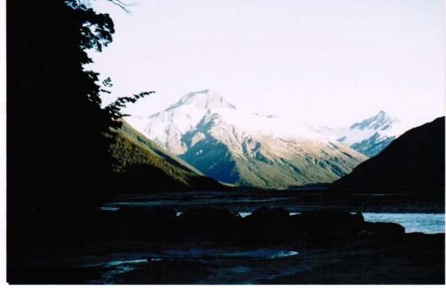
Hopkins looking up toward Mt Ward
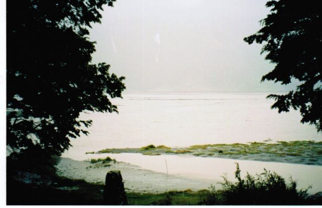
Hopkins under water from one mountain range to the other
Cheers Richard
Re: Wilberforce Track
Posted: Tue Apr 03, 2012 1:47 pm
by dtchch
Thanks for all the info guys. Won't be making the trip this roar but maybe on the cards in the following weeks.
Probably best I stay away from river crossings, I almost got stuck in the Waimak in the weekend how embarrassing that would of been in a foot of water friggin horrible sinky shingle had me worried!
Any of you guys heading out this weekend have a good one